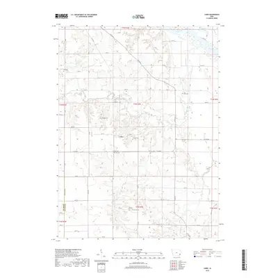
2018 Map of Cairo
USGS Topo · Published 2018About this map
The small settlement of Cairo serves as the focal point for this rural landscape in southeastern Louisa County. Situated near the intersection of Co RD g62 and Co RD x37, the area is defined by its deep agricultural roots and a high density of family and community burial grounds. These include the centrally located Cairo Cem, the northern Grim Cem, and the southern Marshall Cem and Virginia Grove Cem. The terrain is shaped by the drainage patterns of Long Creek and Johnny Cr as they move toward the Iowa River in the northeast corner of the sheet. Genealogists will find particular value in the numerous small cemeteries such as Griswold Cem and Slaughter Cem that dot the townships, preserving the names of the pioneer families who established the section lines and farmsteads found throughout this 2018 survey.
Find a feature on this map
43 named features on this map. Tap any name to fly to it.
Don’t see what you’re looking for? This feature index may not catch every label — zoom into the map to look around manually.
Map Details
Editions of this 2018 Cairo Map
This is the sole edition of this map. No revisions or reprints were ever made.
Other maps of this area

1946 · Wapello
USGS Topo · 1:62,500

1948 · Muscatine
USGS Topo · 1:62,500

1949 · Wapello
USGS Topo · 1:62,500

1958 · Davenport
USGS Topo · 1:250,000

1961 · Davenport
USGS Topo · 1:250,000

1962 · Davenport
USGS Topo · 1:250,000
1965 · Mediapolis
USGS Topo · 1:24,000

1965 · Letts
USGS Topo · 1:24,000
1965 · Wapello
USGS Topo · 1:24,000

1970 · Cotter
USGS Topo · 1:24,000