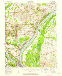
1953 Map of Cairo
USGS Topo · Published 1962About this map
Cairo sits at the dramatic confluence of the Ohio River and the Mississippi River, a landscape defined by massive flood control infrastructure and the convergence of major rail lines like the Illinois Central and the Mobile & Ohio. The strategic importance of the river junction is evident in the dense network of levees and floodgates protecting Mound City and Future City. Beyond the industrial waterfront, the map reveals a rural interior dotted with family-named schools and churches, such as Chambliss School and Mt. Zion Church & Cemetery. In Kentucky, the terrain shifts into a labyrinth of sloughs and bottomland lakes, including Clear Lake and Swan Pond, while the National Cemetery stands as a significant landmark near the Cache River. The survey also marks the presence of Dam No. 53 on the Ohio, illustrating the mid-century engineering of these vital waterways.
Find a feature on this map
105 named features on this map. Tap any name to fly to it.
Don’t see what you’re looking for? This feature index may not catch every label — zoom into the map to look around manually.
Map Details
Editions of this 1953 Cairo Map
3 editions found
Other maps of this area

1918 · Vienna
USGS Topo · 1:62,500

1919 · Vienna
USGS Topo · 1:62,500

1920 · Jonesboro
USGS Topo · 1:62,500

1920 · Dongola
USGS Topo · 1:62,500

1923 · Dongola
USGS Topo · 1:62,500

1923 · Jonesboro
USGS Topo · 1:62,500

1928 · La Center
USGS Topo · 1:62,500

1931 · Cairo
USGS Topo · 1:62,500

1932 · La Center
USGS Topo · 1:62,500

1933 · Cairo
USGS Topo · 1:62,500