
1933 Map of Calabasas
USGS Topo · Published 1933About this map
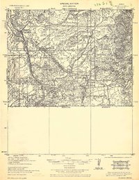
Nogales anchors this 1933 tactical map, revealing a busy border landscape where military presence, ranching, and mining intersected during the interwar years. The presence of Camp Stephen D. Little and a Target Range underscores the area's strategic importance near the United States Mexico boundary. This edition captures the infrastructure of the early 20th century, from the Southern Pacific railroad lines and Benedict Spur to industrial sites like the Brick Yards and Texas Co Oil Tanks.
Find a feature on this map
59 named features on this map. Tap any name to fly to it.
Don’t see what you’re looking for? This feature index may not catch every label — zoom into the map to look around manually.
Map Details
Editions of this 1933 Calabasas Map
2 editions found
Other maps of this area

1904 · Patagonia
USGS Topo · 1:125,000

1905 · Patagonia
USGS Topo · 1:125,000

1905 · Nogales
USGS Topo · 1:125,000

1920 · Arivaca
USGS Topo · 1:125,000

1921 · Old Glory
USGS Topo · 1:125,000

1922 · Agus Caliente
USGS Topo · 1:62,500

1932 · Lochiel
USGS Topo · 1:62,500

1932 · Elgin
USGS Topo · 1:62,500

1939 · Tubac
USGS Topo · 1:62,500

1940 · Elgin
USGS Topo · 1:62,500