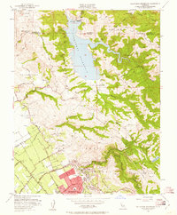
1953 Map of Calaveras Reservoir
USGS Topo · Published 1961About this map
Calaveras Reservoir dominates the center of this landscape, its waters controlled by a Diversion Dam and a Diversion Tunnel leading from Alameda Creek. The map documents a pivotal moment in the Santa Clara Valley's transition, showing the agricultural grid of the Pueblo Lands of San Jose meeting the burgeoning residential development near Berryessa. While the eastern hills remain largely open ranch land divided by family holdings and Mexican land grants like Tularcitos (Higuerra), the southwestern corner reveals the early suburban footprint of Alum Rock. Cultural landmarks such as the San Jose Country Club and Alum Rock Park are clearly defined alongside rural infrastructure including the Air Point Sch and a scattered network of gravel pits and water tanks that supported the region's mid-century growth.
Find a feature on this map
53 named features on this map. Tap any name to fly to it.
Don’t see what you’re looking for? This feature index may not catch every label — zoom into the map to look around manually.
Map Details
Editions of this 1953 Calaveras Reservoir Map
2 editions found
Other maps of this area

1889 · San Jose
USGS Topo · 1:62,500

1897 · San Jose
USGS Topo · 1:62,500

1897 · Mt. Hamilton
USGS Topo · 1:62,500

1899 · San Jose
USGS Topo · 1:62,500

1906 · Pleasanton
USGS Topo · 1:62,500

1907 · Tesla
USGS Topo · 1:62,500

1941 · Pleasanton
USGS Topo · 1:62,500

1942 · Mt. Hamilton
USGS Topo · 1:62,500

1942 · Altamont
USGS Topo · 1:62,500

1943 · Pleasanton
USGS Topo · 1:62,500