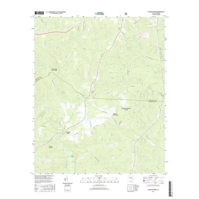
2017 Map of Calhoun Creek
USGS Topo · Published 2017About this map
Calhoun Mill stands as a primary landmark in this corner of the South Carolina Piedmont, situated where the Little River and Calhoun Cr converge. The landscape is defined by the boundary between Abbeville and McCormick counties, featuring a network of rural settlements such as Mount Carmel and Charleston Crossroads. The area's history is anchored by several community burial grounds, including Calhoun Cem and Hopewell Cem, which provide essential points of reference for genealogical research. Much of the eastern terrain falls within the Sumter National Forest, where the topography is dissected by numerous watercourses like Lee Cr and White Cr. This contemporary survey preserves the names of early family-named crossings and junctions, such as Mars Bridge and Belcher Crossroads, illustrating the enduring spatial patterns of this agricultural and timber-producing region.
Find a feature on this map
54 named features on this map. Tap any name to fly to it.
Don’t see what you’re looking for? This feature index may not catch every label — zoom into the map to look around manually.
Map Details
Editions of this 2017 Calhoun Creek Map
This is the sole edition of this map. No revisions or reprints were ever made.
Other maps of this area

1892 · Mc Cormick
USGS Topo · 1:125,000

1892 · Abbeville
USGS Topo · 1:125,000

1893 · Elberton
USGS Topo · 1:125,000

1906 · Crawfordville
USGS Topo · 1:125,000

1912 · Mc Cormick
USGS Topo · 1:125,000

1948 · Abbeville East
USGS Topo · 1:24,000

1948 · Verdery
USGS Topo · 1:24,000

1948 · Abbeville West
USGS Topo · 1:24,000

1949 · Abbeville
USGS Topo · 1:24,000

1949 · Calhoun Creek
USGS Topo · 1:24,000