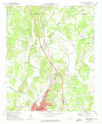
1972 Map of Calhoun North
USGS Topo · Published 1974About this map
New Echota Historical Site and the Cherokee Indian Memorial stand as significant markers of regional heritage along the Oostanaula River. This 1970s survey details a landscape defined by the confluence of the Conasauga River, Coosawattee River, and Oostanaula River, north of Calhoun. The transportation network is anchored by the Louisville and Nashville railroad and the historical Nashville and Louisville Road. Civil War history is preserved at the Resaca Confederate Cem near the community of Resaca. For genealogists, the map identifies numerous family-named landmarks and rural burial grounds such as Chandler Cem, Fain Cem, and New Echota Cem. Smaller settlements like Nance Springs, Angelville, and Damascus appear alongside industrial and municipal features including the Filtration Plant and City Hall Courthouse in the growing hub of Calhoun.
Find a feature on this map
65 named features on this map. Tap any name to fly to it.
Don’t see what you’re looking for? This feature index may not catch every label — zoom into the map to look around manually.
Map Details
Editions of this 1972 Calhoun North Map
3 editions found

Other maps of this area

1886 · Dalton
USGS Topo · 1:125,000

1886 · Ringgold
USGS Topo · 1:125,000

1886 · Rome
USGS Topo · 1:125,000

1890 · Cartersville
USGS Topo · 1:125,000

1891 · Cartersville
USGS Topo · 1:125,000

1892 · Ringgold
USGS Topo · 1:125,000

1892 · Dalton
USGS Topo · 1:125,000

1896 · Cartersville
USGS Topo · 1:125,000

1897 · Dalton
USGS Topo · 1:125,000

1898 · Rome
USGS Topo · 1:125,000