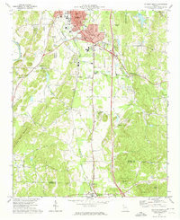
1972 Map of Calhoun South
USGS Topo · Published 1974About this map
The Oostanaula River flows along the western edge of this corridor between Calhoun and Adairsville, where the Louisville and Nashville railroad tracks parallel the winding course of Oothkalooga Creek. This era of the early 1970s shows a landscape of small rural settlements like Lily Pond, McDaniels, and Lynn, interspersed with numerous country houses of worship such as St Clements Ch and Philadelphia Ch.
Find a feature on this map
41 named features on this map. Tap any name to fly to it.
Don’t see what you’re looking for? This feature index may not catch every label — zoom into the map to look around manually.
Map Details
Editions of this 1972 Calhoun South Map
2 editions found
Other maps of this area

1886 · Dalton
USGS Topo · 1:125,000

1886 · Ringgold
USGS Topo · 1:125,000

1886 · Rome
USGS Topo · 1:125,000

1890 · Cartersville
USGS Topo · 1:125,000

1891 · Cartersville
USGS Topo · 1:125,000

1892 · Ringgold
USGS Topo · 1:125,000

1892 · Dalton
USGS Topo · 1:125,000

1896 · Cartersville
USGS Topo · 1:125,000

1897 · Dalton
USGS Topo · 1:125,000

1898 · Rome
USGS Topo · 1:125,000