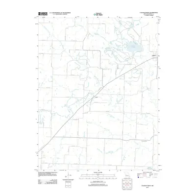
2011 Map of Calhoun West
USGS Topo · Published 2011About this map
Calhoun sits at the eastern edge of this Henry County landscape, where the rural character of west-central Missouri is defined by a dense network of watercourses. The drainage of West Fork Tebo Creek and its many tributaries, including Sand Creek and Nelson Creek, carves a complex topography through the agricultural grid. To the west, the smaller settlement of Lewis marks a point of historical interest for those tracing the development of the county's early communities. The map also captures specialized land use in the form of named reservoirs like Number 111 Lake and O'Dell Lake. For genealogists, the inclusion of Combs Cemetery provides a specific point of reference for local family history research. The road system, dominated by routes like Ne HWY J, reveals how the modern township is organized around these legacy water and settlement patterns.
Find a feature on this map
58 named features on this map. Tap any name to fly to it.
Don’t see what you’re looking for? This feature index may not catch every label — zoom into the map to look around manually.
Map Details
Editions of this 2011 Calhoun West Map
This is the sole edition of this map. No revisions or reprints were ever made.
Other maps of this area

1885 · Warrensburg
USGS Topo · 1:125,000

1887 · Clinton
USGS Topo · 1:125,000

1887 · Warrensburg
USGS Topo · 1:125,000

1894 · Warrensburg
USGS Topo · 1:125,000

1894 · Clinton
USGS Topo · 1:125,000

1947 · Jefferson City
USGS Topo · 1:250,000

1953 · Gaines
USGS Topo · 1:24,000
1953 · Calhoun East
USGS Topo · 1:24,000

1953 · Clinton South
USGS Topo · 1:24,000

1953 · Calhoun West
USGS Topo · 1:24,000