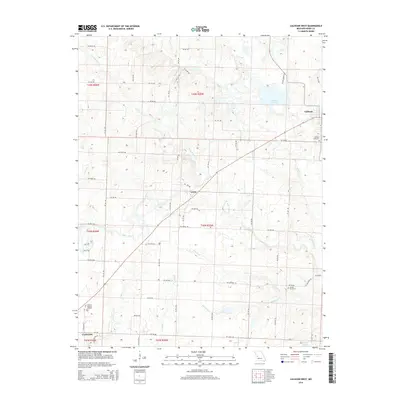
2014 Map of Calhoun West
USGS Topo · Published 2014About this map
Clinton anchors the southwestern corner of this Henry County landscape, where the urban grid gives way to a sprawling network of agricultural roads and creek valleys. This 2014 survey captures the rural character of the region between the county seat and Calhoun, linked by a prominent diagonal highway passing through Lewis. The terrain is defined by the winding course of W Fork Tebo Cr and its numerous tributaries, including Nelson Cr and Harrelson Cr, which carve gentle draws through the prairie land. Genealogists and local researchers will find several significant burial sites documented, such as Clinton Memory Gardens on the outskirts of town, the Calhoun Cemetery, and the more secluded Combs Cemetery located near Nelson Cr. The presence of bodies of water like Number 111 Lake and O'Dell Lake further distinguishes the hydrology of this Missouri quadrangle.
Find a feature on this map
63 named features on this map. Tap any name to fly to it.
Don’t see what you’re looking for? This feature index may not catch every label — zoom into the map to look around manually.
Map Details
Editions of this 2014 Calhoun West Map
This is the sole edition of this map. No revisions or reprints were ever made.
Other maps of this area

1885 · Warrensburg
USGS Topo · 1:125,000

1887 · Clinton
USGS Topo · 1:125,000

1887 · Warrensburg
USGS Topo · 1:125,000

1894 · Warrensburg
USGS Topo · 1:125,000

1894 · Clinton
USGS Topo · 1:125,000

1947 · Jefferson City
USGS Topo · 1:250,000

1953 · Gaines
USGS Topo · 1:24,000
1953 · Calhoun East
USGS Topo · 1:24,000

1953 · Clinton South
USGS Topo · 1:24,000

1953 · Calhoun West
USGS Topo · 1:24,000