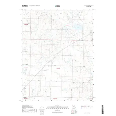
2017 Map of Calhoun West
USGS Topo · Published 2017About this map
The Missouri prairie landscape of Henry County is defined here by the headwaters of the Tebo Creek system, including the W Fork Tebo Cr and its various tributaries like Nelson Cr and Harrelson Cr. The town of Calhoun anchors the northeastern corner of the map, situated at the junction of Ne HWY J and Ne HWY V, while the smaller settlement of Lewis sits further west. This area reflects a long-standing agricultural and rural pattern, punctuated by local family-history markers such as Combs Cem and Calhoun Cem. The southern edge of the survey transitions into the outskirts of Clinton, where Clinton Memory Gardens and the waters of Deer Cr mark the landscape. Water resources for the region are further represented by Number 111 Lake and O'Dell Lake, highlighting the local reliance on both natural stream networks and man-made reservoirs.
Find a feature on this map
69 named features on this map. Tap any name to fly to it.
Don’t see what you’re looking for? This feature index may not catch every label — zoom into the map to look around manually.
Map Details
Editions of this 2017 Calhoun West Map
This is the sole edition of this map. No revisions or reprints were ever made.
Other maps of this area

1885 · Warrensburg
USGS Topo · 1:125,000

1887 · Clinton
USGS Topo · 1:125,000

1887 · Warrensburg
USGS Topo · 1:125,000

1894 · Warrensburg
USGS Topo · 1:125,000

1894 · Clinton
USGS Topo · 1:125,000

1947 · Jefferson City
USGS Topo · 1:250,000

1953 · Gaines
USGS Topo · 1:24,000
1953 · Calhoun East
USGS Topo · 1:24,000

1953 · Clinton South
USGS Topo · 1:24,000

1953 · Calhoun West
USGS Topo · 1:24,000