
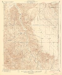
1943 Map of Caliente Mtn.
USGS Topo · Published 1943About this map
Soda Lake dominates the northern basin of this 1943 survey, sitting at the heart of the Carrizo Plain between the Temblor Range and the Caliente Range. The landscape is defined by vast cattle ranching operations and isolated water sources, including the Goodwin Ranch, Chimeneas Ranch, and Wellman Ranch, alongside essential desert waypoints like Turkey Camp Well and Five Willow Spring.
Find a feature on this map
38 named features on this map. Tap any name to fly to it.
Don’t see what you’re looking for? This feature index may not catch every label — zoom into the map to look around manually.
Map Details
Editions of this 1943 Caliente Mtn. Map
This is the sole edition of this map. No revisions or reprints were ever made.
Other maps of this area

1902 · Santa Ynez
USGS Topo · 1:125,000

1905 · Santa Ynez
USGS Topo · 1:125,000

1905 · Lompoc
USGS Topo · 1:125,000

1912 · McKittrick
USGS Topo · 1:125,000

1932 · La Panza
USGS Topo · 1:48,000

1935 · La Panza
USGS Topo · 1:62,500
1936 · La Panza
USGS Topo · 1:62,500

1937 · Branch Mtn
USGS Topo · 1:48,000

1941 · Caliente Mountain
USGS Topo · 1:62,500
1941 · McPherson Peak
USGS Topo · 1:62,500