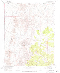
1970 Map of Caliente NW
USGS Topo · Published 1973About this map
The Burnt Springs Range and Delamar Mountains dominate this high-desert landscape in Lincoln County. In a region where water sources dictated movement and survival, this survey records several critical points including Rabbit Spring, Cliff Springs, and Dana Spring. An aqueduct traces a path through the western foothills, while a network of Jeep Trails provides access to remote mineral interests indicated by several Prospect and prospects sites. The terrain is marked by significant elevation changes, from the heights of Sugarloaf down into Antelope Canyon and the eastern edge of the Dry Lake (Depression) Valley. These features reveal a landscape shaped by both natural drainage patterns like Porphyry Wash and human infrastructure like the Crows Nest Tank, reflecting the mid-century intersection of ranching and exploration in Nevada's Great Basin.
Find a feature on this map
16 named features on this map. Tap any name to fly to it.
Don’t see what you’re looking for? This feature index may not catch every label — zoom into the map to look around manually.
Map Details
Editions of this 1970 Caliente NW Map
2 editions found
Other maps of this area

1885 · Pioche
USGS Topo · 1:250,000

1886 · Pioche
USGS Topo · 1:250,000

1916 · Highland
USGS Topo · 1:62,500

1918 · Highland
USGS Topo · 1:62,500

1954 · Caliente
USGS Topo · 1:250,000

1959 · Caliente
USGS Topo · 1:250,000
1970 · The Bluffs
USGS Topo · 1:24,000
1970 · Bennett Pass
USGS Topo · 1:24,000
1970 · Deadman Spring SE
USGS Topo · 1:24,000
1970 · Pahroc Spring SE
USGS Topo · 1:24,000