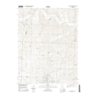
2015 Map of California North
USGS Topo · Published 2015About this map
The city of California serves as the focal point of this Moniteau County survey, showing the community just north of the county seat. The landscape is defined by the branching networks of Moniteau Creek and E Brush Creek, which cut through the agricultural uplands. A striking concentration of family and community burial sites, including Strickfaden Cemetery, Rohrback Cemetery, and Schmutz Cemetery, indicates the long-standing genealogical roots of this Missouri region. The rural road network often follows geographic landmarks and property histories, with names like Gooseberry Hollow Road and Cheese Factory Road reflecting the local economic heritage. Notable infrastructure includes the Steelhouse Bridge and the W Railroad Avenue corridor, which underscores the historical importance of the rail line to the development of California and the surrounding smaller settlements like Kliever.
Find a feature on this map
97 named features on this map. Tap any name to fly to it.
Don’t see what you’re looking for? This feature index may not catch every label — zoom into the map to look around manually.
Map Details
Editions of this 2015 California North Map
This is the sole edition of this map. No revisions or reprints were ever made.
Other maps of this area

1886 · Jefferson City
USGS Topo · 1:125,000

1888 · Boonville
USGS Topo · 1:125,000

1894 · Jefferson City
USGS Topo · 1:125,000

1947 · Jefferson City
USGS Topo · 1:250,000

1948 · Centertown
USGS Topo · 1:62,500

1948 · Columbia
USGS Topo · 1:62,500
1949 · Centertown
USGS Topo · 1:62,500

1950 · Columbia
USGS Topo · 1:62,500

1951 · California South
USGS Topo · 1:24,000

1951 · Latham
USGS Topo · 1:24,000