
1927 Map of Calistoga
USGS Topo · Published 1927About this map
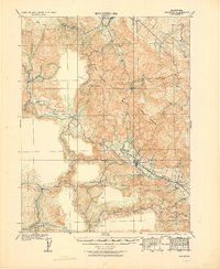
Mt St Helena dominates the northern reaches of this Napa Valley landscape, overlooking a region defined by early mining interests and agrarian estates in the mid-1920s. The presence of the Chicago and Helena Quicksilver Mines, along with the Oat Hill Mine and Coronado Mine, highlights a period when mercury extraction was a significant industrial driver in the rugged hills surrounding Calistoga.
Find a feature on this map
28 named features on this map. Tap any name to fly to it.
Don’t see what you’re looking for? This feature index may not catch every label — zoom into the map to look around manually.
Map Details
Editions of this 1927 Calistoga Map
2 editions found
Other maps of this area

1902 · Napa
USGS Topo · 1:125,000

1916 · Santa Rosa
USGS Topo · 1:62,500

1920 · Healdsburg
USGS Topo · 1:62,500

1921 · Kelseyville
USGS Topo · 1:62,500

1933 · Healdsburg
USGS Topo · 1:48,000

1935 · Sebastopol
USGS Topo · 1:48,000

1940 · Healdsburg
USGS Topo · 1:62,500

1942 · Sebastopol
USGS Topo · 1:62,500

1942 · Sonoma
USGS Topo · 1:62,500

1942 · St. Helena
USGS Topo · 1:62,500