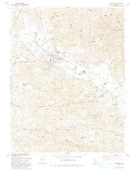
1993 Map of Calistoga
USGS Topo · Published 1993About this map
Calistoga serves as the focal point of this northern valley landscape, situated where the Napa River flows between the slopes of Diamond Mountain and Rattlesnake Ridge. The map details a transition from the structured street grid of the town, including its High Sch and Fairgrounds, to the agricultural and recreational lands that define the region. Notably, the presence of the Schramsberg Winery Historical Marker and the Bale Grist Mill State Historical Park highlights the early industrial and viticultural roots of the area. Industrial history is further marked by the Palisade Mine and Kellet Mine tucked into the surrounding canyons. Transportation is anchored by the Southern Pacific rail line and the iconic Silverado Trail, while the inclusion of a Landing Strip and Sewage Disposal plant reflects the infrastructure of a maturing community in the early 1990s.
Find a feature on this map
69 named features on this map. Tap any name to fly to it.
Don’t see what you’re looking for? This feature index may not catch every label — zoom into the map to look around manually.
Map Details
Editions of this 1993 Calistoga Map
This is the sole edition of this map. No revisions or reprints were ever made.
Other maps of this area

1902 · Napa
USGS Topo · 1:125,000

1916 · Santa Rosa
USGS Topo · 1:62,500

1927 · Calistoga
USGS Topo · 1:62,500

1942 · Sonoma
USGS Topo · 1:62,500

1942 · St. Helena
USGS Topo · 1:62,500

1943 · Calistoga
USGS Topo · 1:62,500

1944 · Santa Rosa
USGS Topo · 1:62,500

1945 · Calistoga
USGS Topo · 1:62,500

1945 · St. Helena
USGS Topo · 1:62,500

1947 · Santa Rosa
USGS Topo · 1:250,000