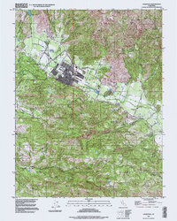
1997 Map of Calistoga
USGS Topo · Published 1998About this map
The northern reaches of the Napa Valley define this landscape, centered on the historic resort town of Calistoga. By the late 20th century, the area's transition from a thermal springs destination to a premier viticultural region is evident through markers like the Schramsberg Winery Historical Marker and various winery sites. The Napa River flows through the valley floor, flanked by the iconic Silverado Trail and Bennett Lane.
Find a feature on this map
25 named features on this map. Tap any name to fly to it.
Don’t see what you’re looking for? This feature index may not catch every label — zoom into the map to look around manually.
Map Details
Editions of this 1997 Calistoga Map
This is the sole edition of this map. No revisions or reprints were ever made.
Other maps of this area

1902 · Napa
USGS Topo · 1:125,000

1916 · Santa Rosa
USGS Topo · 1:62,500

1927 · Calistoga
USGS Topo · 1:62,500

1942 · Sonoma
USGS Topo · 1:62,500

1942 · St. Helena
USGS Topo · 1:62,500

1943 · Calistoga
USGS Topo · 1:62,500

1944 · Santa Rosa
USGS Topo · 1:62,500

1945 · Calistoga
USGS Topo · 1:62,500

1945 · St. Helena
USGS Topo · 1:62,500

1947 · Santa Rosa
USGS Topo · 1:250,000