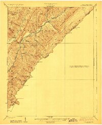
1923 Map of Callaghan
USGS Topo · Published 1923About this map
Anthony Creek and its numerous tributaries define the complex mountain topography of this 1920s-era borderland between West Virginia and Virginia. The settlement pattern is characterized by small, isolated communities like Neola, Alvon, and Slabcamp, each connected by narrow valley roads including the historic Huntersville Road. A striking density of rural educational structures is evident across the terrain, from Slabcamp School in the north to the Wild Meadow School further south, reflecting the decentralized school system required by the high ridges of Meadow Creek Mountain and Falling Springs Mountain.
Find a feature on this map
59 named features on this map. Tap any name to fly to it.
Don’t see what you’re looking for? This feature index may not catch every label — zoom into the map to look around manually.
Map Details
Editions of this 1923 Callaghan Map
3 editions found

Other maps of this area

1887 · Lewisburg
USGS Topo · 1:125,000

1891 · Lewisburg
USGS Topo · 1:125,000

1891 · Huntersville
USGS Topo · 1:125,000

1894 · Huntersville
USGS Topo · 1:125,000

1894 · Natural Bridge
USGS Topo · 1:125,000

1901 · Monterey
USGS Topo · 1:125,000

1913 · Eagle Rock
USGS Topo · 1:48,000

1915 · Eagle Rock
USGS Topo · 1:62,500

1921 · Callaghan
USGS Topo · 1:48,000

1921 · White Sulphur Springs
USGS Topo · 1:48,000