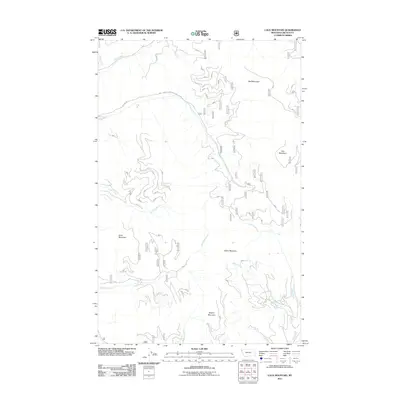
2011 Map of Calx Mountain
USGS Topo · Published 2011About this map
Wolf Mountain and Calx Mountain dominate this section of Lincoln County, defining a landscape of high summits and deep drainage basins in northwestern Montana. The area is characterized by a dense network of forest development routes, including the Natl Forest Develop Road 762 RD, which provides access to the steep slopes of Satire Mountain and Rogers Mountain. A complex system of watercourses, including Wolf Creek, Cow Creek, and Snell Creek, flows through the terrain, originating from the ridges of Snell Mountain and its surrounding peaks. The detailed mapping of these creek systems and the numerous numbered forest roads suggests a region heavily managed for timber or conservation, where traditional named landmarks like Chief Creek and Sipes Creek intersect with modern administrative infrastructure.
Find a feature on this map
63 named features on this map. Tap any name to fly to it.
Don’t see what you’re looking for? This feature index may not catch every label — zoom into the map to look around manually.
Map Details
Editions of this 2011 Calx Mountain Map
This is the sole edition of this map. No revisions or reprints were ever made.
Other maps of this area

1920 · Jennings
USGS Topo · 1:125,000

1935 · Thompson Lakes
USGS Topo · 1:96,000

1942 · Thompson Lakes
USGS Topo · 1:125,000

1957 · Kalispell
USGS Topo · 1:250,000

1960 · Kalispell
USGS Topo · 1:250,000

1961 · Kalispell
USGS Topo · 1:250,000

1963 · Wolf Prairie
USGS Topo · 1:24,000
1963 · Tony Peak
USGS Topo · 1:24,000
1963 · Richards Mountain
USGS Topo · 1:24,000
1966 · Fisher Mountain
USGS Topo · 1:24,000