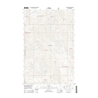
2014 Map of Calx Mountain
USGS Topo · Published 2014About this map
Kootenai National Forest dominates this topographic study of Lincoln County, defining a landscape of high summits and deeply carved drainages. The map centers on the high elevations of Calx Mtn and Wolf Mtn, where the steep relief dictates the path of early forest infrastructure. A network of service roads, including Wolf Creek Rd and the Natl Forest Develop Road 5801 Rd, follows the natural contours carved by Wolf Cr and Cow Cr. This 2014 survey reveals the hydrological complexity of the region, from the headwaters of Snell Cr beneath Snell Mtn to the southern reaches of Wabuna Cr and McKillop Cr. The arrangement of these features illustrates the ongoing importance of watershed management and forest access in northwestern Montana's backcountry.
Find a feature on this map
23 named features on this map. Tap any name to fly to it.
Don’t see what you’re looking for? This feature index may not catch every label — zoom into the map to look around manually.
Map Details
Editions of this 2014 Calx Mountain Map
This is the sole edition of this map. No revisions or reprints were ever made.
Other maps of this area

1920 · Jennings
USGS Topo · 1:125,000

1935 · Thompson Lakes
USGS Topo · 1:96,000

1942 · Thompson Lakes
USGS Topo · 1:125,000

1957 · Kalispell
USGS Topo · 1:250,000

1960 · Kalispell
USGS Topo · 1:250,000

1961 · Kalispell
USGS Topo · 1:250,000

1963 · Wolf Prairie
USGS Topo · 1:24,000
1963 · Tony Peak
USGS Topo · 1:24,000
1963 · Richards Mountain
USGS Topo · 1:24,000
1966 · Fisher Mountain
USGS Topo · 1:24,000