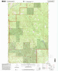
1997 Map of Calx Mountain
USGS Topo · Published 2000About this map
The Kootenai National Forest dominates this section of Lincoln County, defined by a series of prominent peaks and drainage systems in northwestern Montana. High elevations are anchored by Wolf Mountain in the north and the namesake Calx Mountain to the east, while Rogers Mountain and Satire Mountain rise in the southern reaches. The landscape is carved by a network of seasonal and perennial streams including Wolf Creek and Cow Creek. Mapping revisions in the late 1990s emphasize the 4WD routes and forest service infrastructure necessary for navigating this mountainous terrain. Public land surveys here are oriented around the Seventh Standard Parallel North, providing a precise look at the township and range divisions that governed development and land use within the national forest system during the late twentieth century.
Find a feature on this map
21 named features on this map. Tap any name to fly to it.
Don’t see what you’re looking for? This feature index may not catch every label — zoom into the map to look around manually.
Map Details
Editions of this 1997 Calx Mountain Map
This is the sole edition of this map. No revisions or reprints were ever made.
Other maps of this area

1920 · Jennings
USGS Topo · 1:125,000

1935 · Thompson Lakes
USGS Topo · 1:96,000

1942 · Thompson Lakes
USGS Topo · 1:125,000

1957 · Kalispell
USGS Topo · 1:250,000

1960 · Kalispell
USGS Topo · 1:250,000

1961 · Kalispell
USGS Topo · 1:250,000

1963 · Wolf Prairie
USGS Topo · 1:24,000
1963 · Tony Peak
USGS Topo · 1:24,000
1963 · Richards Mountain
USGS Topo · 1:24,000
1966 · Fisher Mountain
USGS Topo · 1:24,000