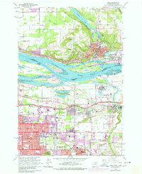
1961 Map of Camas
USGS Topo · Published 1977About this map
The Columbia River corridor serves as the industrial and geographical heart of this 1961 survey, updated through the mid-1970s. Industrial development is prominent along the shores, anchored by the massive Aluminum Plant in Troutdale and the Port of Camas/Washougal. The transition from the high grounds of Prune Hill and Mill Plain in Washington down to the river islands like Government Island and Lady Island illustrates the complex hydrology of the sloughs and channels that defined local transport.
Find a feature on this map
70 named features on this map. Tap any name to fly to it.
Don’t see what you’re looking for? This feature index may not catch every label — zoom into the map to look around manually.
Map Details
Editions of this 1961 Camas Map
3 editions found
Other maps of this area

1897 · Portland
USGS Topo · 1:62,500

1905 · Portland
USGS Topo · 1:62,500

1911 · Boring
USGS Topo · 1:48,000

1914 · Boring
USGS Topo · 1:62,500

1914 · Oregon City
USGS Topo · 1:62,500

1916 · Estacada
USGS Topo · 1:125,000

1918 · Troutdale
USGS Topo · 1:62,500

1934 · Troutdale
USGS Topo · 1:48,000

1939 · Oregon City
USGS Topo · 1:62,500

1940 · Boring
USGS Topo · 1:62,500