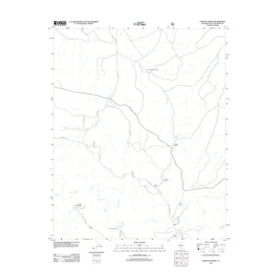
2012 Map of Camatta Ranch
USGS Topo · Published 2012About this map
Camatta Ranch anchors this interior landscape of San Luis Obispo County, where the drainage networks of Shell Cr and Fernandez Cr carve through the foothills east of Black Mountain. The area is characterized by scattered rural homesteads and agricultural operations, including the Bethal Ranch and the Redwind Foundation. Transportation is defined by winding ranch roads such as Fernandez Rd and Red Hill Rd, reflecting a landscape dedicated to cattle ranching and conservation. A high density of named water sources, including Wild Horse Spring, Dave Littlejohn Spring, and Blue Oak Spring, reveals the critical importance of reliable water in this arid California environment. Recreational and utility infrastructure is represented by the Friis Campground and a remote Camatta Ranch Airstrip, serving the isolated properties of the Carrizo Plain region.
Find a feature on this map
36 named features on this map. Tap any name to fly to it.
Don’t see what you’re looking for? This feature index may not catch every label — zoom into the map to look around manually.
Map Details
Editions of this 2012 Camatta Ranch Map
This is the sole edition of this map. No revisions or reprints were ever made.
Other maps of this area

1914 · Cholame
USGS Topo · 1:125,000

1915 · Cholame
USGS Topo · 1:125,000

1917 · Cholame
USGS Topo · 1:125,000

1922 · Pozo
USGS Topo · 1:62,500

1932 · La Panza
USGS Topo · 1:48,000

1935 · La Panza
USGS Topo · 1:62,500

1936 · La Panza
USGS Topo · 1:62,500

1943 · Grant Lake
USGS Topo · 1:31,680

1943 · Commatti Canyon
USGS Topo · 1:31,680

1943 · Shedd Canyon
USGS Topo · 1:31,680