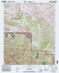
1995 Map of Camatta Ranch
USGS Topo · Published 2000About this map
The La Panza Range and Black Mountain dominate this mid-1990s survey of eastern San Luis Obispo County. This landscape is characterized by a network of drainage canyons and high-elevation springs that sustained regional ranching and early forest management, as evidenced by the namesake Camatta Ranch and nearby Bonsal Ranch. Within the Los Padres National Forest boundaries, a sophisticated infrastructure for fire and aviation management is visible, including a Landing Strip and a Communication Site FAA Installation. The map also preserves the boundary of the historical Panza Grant, a relic of earlier land tenure systems in California. Remote trails like the Fernandez Trail and numerous water sources such as Wild Horse Spring and Blue Oak Spring show how the backcountry was navigated before modern road development.
Find a feature on this map
39 named features on this map. Tap any name to fly to it.
Don’t see what you’re looking for? This feature index may not catch every label — zoom into the map to look around manually.
Map Details
Editions of this 1995 Camatta Ranch Map
This is the sole edition of this map. No revisions or reprints were ever made.
Other maps of this area

1914 · Cholame
USGS Topo · 1:125,000

1915 · Cholame
USGS Topo · 1:125,000

1917 · Cholame
USGS Topo · 1:125,000

1922 · Pozo
USGS Topo · 1:62,500

1932 · La Panza
USGS Topo · 1:48,000

1935 · La Panza
USGS Topo · 1:62,500

1936 · La Panza
USGS Topo · 1:62,500

1943 · Grant Lake
USGS Topo · 1:31,680

1943 · Commatti Canyon
USGS Topo · 1:31,680

1943 · Shedd Canyon
USGS Topo · 1:31,680