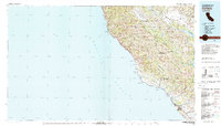
1980 Map of Cambria
USGS Topo · Published 1980About this map
The Santa Lucia Range dominates the Central Coast landscape in this 1980 survey, where the peaks drop sharply toward the Pacific. Along the shore, the California Sea Otter Game Refuge protects a stretch of coastline marked by the iconic Hearst-San Simeon State Historical Monument and the historic Lighthouse at Piedras Blancas. The map captures the meeting of land and sea at San Simeon Bay, illustrating the sparse settlement pattern of the era through small communities like Plaskett, Gorda, and Harmony. Inland, the terrain shifts toward large water management and military uses. The Fort Hunter Liggett Military Reservation occupies a massive interior tract, while the San Antonio Reservoir and Nacimiento Reservoir highlight the region's mid-century hydrological engineering. These features together show a coast preserved for history and nature, set against an interior of managed ranch lands and military utility.
Find a feature on this map
34 named features on this map. Tap any name to fly to it.
Don’t see what you’re looking for? This feature index may not catch every label — zoom into the map to look around manually.
Map Details
Editions of this 1980 Cambria Map
2 editions found
Other maps of this area

1897 · Cayucos
USGS Topo · 1:62,500

1900 · San Luis
USGS Topo · 1:125,000

1912 · San Ardo
USGS Topo · 1:31,680

1915 · Priest Valley
USGS Topo · 1:125,000

1919 · King City
USGS Topo · 1:62,500

1919 · Junipero Serra
USGS Topo · 1:62,500

1919 · Bryson
USGS Topo · 1:62,500

1919 · Bradley
USGS Topo · 1:62,500

1919 · Adelaida
USGS Topo · 1:62,500

1919 · Piedras Blancas
USGS Topo · 1:62,500