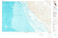
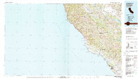
1980 Map of Cambria
USGS Topo · Published 1987About this map
The Santa Lucia Range dominates this coastal survey, where the peaks of the Los Padres National Forest meet the Pacific. This 1980s edition is particularly notable for its integration of bathymetric data, detailing the deep underwater topography of Lucia Canyon and Sur Canyon just off the shoreline. Along the coast, California 1 winds past the Hearst San Simeon State Historical Monument and through the community of Cambria, while the protected waters of the California Sea Otter Game Refuge buffer the cliffs. Inland, the landscape shifts to the wide expanse of the Fort Hunter Liggett Military Reservation and the waters of the San Antonio Reservoir, illustrating the intersection of military land use, water resource management, and conservation efforts along the Central Coast.
Find a feature on this map
26 named features on this map. Tap any name to fly to it.
Don’t see what you’re looking for? This feature index may not catch every label — zoom into the map to look around manually.
Map Details
Editions of this 1980 Cambria Map
2 editions found
Other maps of this area

1897 · Cayucos
USGS Topo · 1:62,500

1900 · San Luis
USGS Topo · 1:125,000

1912 · San Ardo
USGS Topo · 1:31,680

1915 · Priest Valley
USGS Topo · 1:125,000

1919 · King City
USGS Topo · 1:62,500

1919 · Junipero Serra
USGS Topo · 1:62,500

1919 · Bryson
USGS Topo · 1:62,500

1919 · Bradley
USGS Topo · 1:62,500

1919 · Adelaida
USGS Topo · 1:62,500

1919 · Piedras Blancas
USGS Topo · 1:62,500