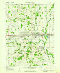
1960 Map of Cambridge City
USGS Topo · Published 1961About this map
Cambridge City serves as a prominent hub for Eastern Indiana's transportation history, centered along the historic National Road Pennsylvania. This 1960 era landscape is defined by the convergence of major rail corridors, including the Pennsylvania Railroad and the New York Chicago and St Louis Railroad. Small 19th-century settlements like Dublin, Milton, and East Germantown are shown in detail, revealing the residential patterns of the Whitewater Valley. Local life is documented through numerous religious and civic landmarks such as Locust Grove Ch, Zion Ch, and the Township Sch. The topography is shaped by the Whitewater River and its many tributaries like Symonds Creek and Martindale Creek, while the inclusion of the Pumping Station and several gravel pits indicates the local infrastructure and industry of the mid-century.
Find a feature on this map
70 named features on this map. Tap any name to fly to it.
Don’t see what you’re looking for? This feature index may not catch every label — zoom into the map to look around manually.
Map Details
Editions of this 1960 Cambridge City Map
2 editions found
Other maps of this area

1948 · Lewisville
USGS Topo · 1:24,000

1950 · New Castle East
USGS Topo · 1:24,000

1950 · Lewisville
USGS Topo · 1:24,000

1953 · Cincinnati
USGS Topo · 1:250,000

1956 · Brownsville
USGS Topo · 1:24,000

1956 · Connersville
USGS Topo · 1:24,000

1957 · Cincinnati
USGS Topo · 1:250,000

1959 · Falmouth
USGS Topo · 1:24,000

1960 · New Castle East
USGS Topo · 1:24,000
1960 · Hagerstown
USGS Topo · 1:24,000