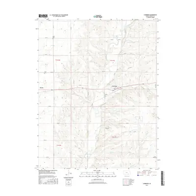
2015 Map of Cambridge
USGS Topo · Published 2015About this map
Flint Hills topography dominates this section of eastern Cowley County, where the prairie landscape is carved by an intricate network of waterways. The town of Cambridge sits at a central crossing, while Burden occupies the western edge of the quadrangle. Local genealogy is well-supported by the presence of several established burial grounds, including Grand Prairie Cem in the north and Gospel Ridge Cem to the southeast. The drainage pattern is particularly dense here, defined by the winding path of Grouse Creek and its many tributaries such as Silver Cr, Blue Br, and Cedar Cr. This 2015 survey illustrates the enduring rural structure of the region, where a grid of section roads like 72nd RD and 281st RD connects isolated ranching operations and small-town centers.
Find a feature on this map
40 named features on this map. Tap any name to fly to it.
Don’t see what you’re looking for? This feature index may not catch every label — zoom into the map to look around manually.
Map Details
Editions of this 2015 Cambridge Map
This is the sole edition of this map. No revisions or reprints were ever made.
Other maps of this area

1889 · Burden
USGS Topo · 1:125,000

1955 · Wichita
USGS Topo · 1:250,000

1958 · Wichita
USGS Topo · 1:250,000

1962 · Grand Summit
USGS Topo · 1:24,000

1962 · Dexter
USGS Topo · 1:24,000
1962 · Dexter NE
USGS Topo · 1:24,000

1962 · Cambridge
USGS Topo · 1:24,000

1964 · Cambridge NW
USGS Topo · 1:24,000
1964 · Cambridge NE
USGS Topo · 1:24,000

1964 · Burden
USGS Topo · 1:24,000