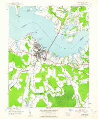
1943 Map of Cambridge
USGS Topo · Published 1962About this map
Cambridge sits as the primary urban center on this mid-century survey, its street grid reaching toward the southern bank of the Choptank River. The landscape reveals a transition from the developed waterfront at Gray Marsh Point to the surrounding rural reaches of Dorchester County. The Choptank River Bridge provides a critical connection across the wide waterway toward Highlys Beach, while the inland areas are defined by agricultural patches and significant community landmarks like the State Hospital and County Fairgrounds.
Find a feature on this map
36 named features on this map. Tap any name to fly to it.
Don’t see what you’re looking for? This feature index may not catch every label — zoom into the map to look around manually.
Map Details
Editions of this 1943 Cambridge Map
3 editions found
Other maps of this area

1898 · Choptank
USGS Topo · 1:125,000

1898 · St. Marys
USGS Topo · 1:125,000

1903 · Nanticoke
USGS Topo · 1:62,500

1904 · Oxford
USGS Topo · 1:62,500

1905 · Crapo
USGS Topo · 1:62,500

1905 · Hurlock
USGS Topo · 1:62,500

1906 · St. Marys
USGS Topo · 1:125,000

1908 · Choptank
USGS Topo · 1:125,000

1942 · Oxford
USGS Topo · 1:31,680

1942 · Church Creek
USGS Topo · 1:24,000