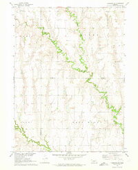
1970 Map of Cambridge NE
USGS Topo · Published 1973About this map
Muddy Creek winds extensively through the heart of this central Nebraska landscape, defining the drainage patterns across the Frontier and Gosper county line. The topography is characterized by the broad upland divides of Earl, Grant, and West Muddy, which separate the riparian corridors. For genealogists and local historians, the Stowe Cem provides a specific point of interest in the northern portion of the survey. The map also records the presence of a Gravel Pit and the path of Deer Creek, illustrating the rural land use and natural resources in this part of the Missouri River Basin during the early 1970s.
Find a feature on this map
8 named features on this map. Tap any name to fly to it.
Don’t see what you’re looking for? This feature index may not catch every label — zoom into the map to look around manually.
Map Details
Editions of this 1970 Cambridge NE Map
This is the sole edition of this map. No revisions or reprints were ever made.
Other maps of this area

1896 · Lexington
USGS Topo · 1:125,000

1896 · Arapahoe
USGS Topo · 1:125,000

1898 · Arapahoe
USGS Topo · 1:125,000

1899 · Lexington
USGS Topo · 1:125,000

1902 · Gothenburg
USGS Topo · 1:125,000

1954 · McCook
USGS Topo · 1:250,000

1955 · Grand Island
USGS Topo · 1:250,000

1956 · Cambridge
USGS Topo · 1:24,000

1956 · Medicine Creek Dam
USGS Topo · 1:24,000

1957 · McCook
USGS Topo · 1:250,000