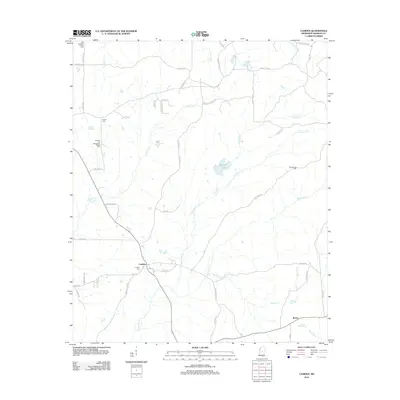
2012 Map of Camden
USGS Topo · Published 2012About this map
Camden sits at a crossroads in northern Madison County, serving as the central hub for a landscape defined by its numerous small creek drainages and community institutions. In the early 21st century, the area retains its rural character, anchored by historic congregations such as Old Truelight Church, Shiloh, and Pleasant Hill Missionary Baptist. The terrain is etched by an intricate network of waterways including Hobuck Cr, Watermill Cr, and Mansell Cr, which weave through the agricultural and forested tracts. Local geography is further marked by the small settlement of Revive in the south and the site of Madison Springs to the west. Genealogists will find particular value in the documentation of the Camden Cem, located just south of the main settlement, reflecting the deep-rooted family histories of this Mississippi interior.
Find a feature on this map
54 named features on this map. Tap any name to fly to it.
Don’t see what you’re looking for? This feature index may not catch every label — zoom into the map to look around manually.
Map Details
Editions of this 2012 Camden Map
This is the sole edition of this map. No revisions or reprints were ever made.
Other maps of this area

1953 · Meridian
USGS Topo · 1:250,000

1957 · Meridian
USGS Topo · 1:250,000

1960 · Sharon
USGS Topo · 1:62,500

1961 · Carthage
USGS Topo · 1:62,500

1962 · Thomastown
USGS Topo · 1:62,500

1964 · Camden
USGS Topo · 1:24,000

1964 · Newport
USGS Topo · 1:24,000
1964 · Goodman
USGS Topo · 1:24,000

1965 · Meridian
USGS Topo · 1:250,000
1966 · Goodman
USGS Topo · 1:62,500