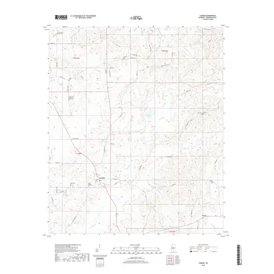
2018 Map of Camden
USGS Topo · Published 2018About this map
Camden sits at the heart of this Madison County landscape, where the agricultural legacy of central Mississippi is visible through a dense network of local roads and family cemeteries. Significant for genealogists and local historians, the area is dotted with historical burial grounds including Old Truelight Church Cem, Great Murphy Chapel Cem, and Wilderwood Cem. The terrain is defined by a dendritic drainage pattern where numerous creeks, such as Watermill Cr, Mansell Creek, and Pellahalia Cr, carve through the countryside. To the southeast lies the small settlement of Revive, while the presence of Madison Springs and Morgans Lake suggests the importance of local water sources to the surrounding homesteads and farms that have long defined this community's footprint.
Find a feature on this map
62 named features on this map. Tap any name to fly to it.
Don’t see what you’re looking for? This feature index may not catch every label — zoom into the map to look around manually.
Map Details
Editions of this 2018 Camden Map
This is the sole edition of this map. No revisions or reprints were ever made.
Other maps of this area

1953 · Meridian
USGS Topo · 1:250,000

1957 · Meridian
USGS Topo · 1:250,000

1960 · Sharon
USGS Topo · 1:62,500

1961 · Carthage
USGS Topo · 1:62,500

1962 · Thomastown
USGS Topo · 1:62,500

1964 · Camden
USGS Topo · 1:24,000

1964 · Newport
USGS Topo · 1:24,000
1964 · Goodman
USGS Topo · 1:24,000

1965 · Meridian
USGS Topo · 1:250,000
1966 · Goodman
USGS Topo · 1:62,500