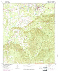
1973 Map of Camden South
USGS Topo · Published 1986About this map
Camden's southern outskirts and the surrounding Wilcox County landscape are defined by a network of rural churchyards and family cemeteries that offer a window into the area's genealogical history. The terrain drops from the residential edge of town near the McIntosh Cem and Radio Tower (WCOX) into a heavily dissected drainage system led by Shoal Creek and Pursley Creek. This 1970s survey captures the region as a patchwork of timber and small agricultural clearings, dotted with localized settlements like Pebble Hill and Wheeler Quarter. Cultural landmarks are frequent, including St James Ch and numerous burial grounds such as Magnolia Cem, Capell Cem, and Little Rock Ch Cem. The presence of several Gravel Pits along the creek beds suggests the importance of local material extraction for maintaining the roads connecting these disparate communities and points like Gallows Bluff.
Find a feature on this map
29 named features on this map. Tap any name to fly to it.
Don’t see what you’re looking for? This feature index may not catch every label — zoom into the map to look around manually.
Map Details
Editions of this 1973 Camden South Map
2 editions found
Other maps of this area

1953 · Montgomery
USGS Topo · 1:250,000

1953 · Andalusia
USGS Topo · 1:250,000

1956 · Montgomery
USGS Topo · 1:250,000

1957 · Montgomery
USGS Topo · 1:250,000

1957 · Andalusia
USGS Topo · 1:250,000

1957 · Carlowville
USGS Topo · 1:62,500

1973 · Coy
USGS Topo · 1:24,000

1973 · Hybart
USGS Topo · 1:24,000

1973 · Camden South
USGS Topo · 1:24,000

1973 · Vredenburgh
USGS Topo · 1:24,000