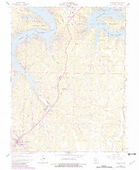
1959 Map of Camdenton
USGS Topo · Published 1982About this map
Linn Creek and Camdenton anchor this mid-century view of the developing Lake of the Ozarks region. The landscape is defined by the irregular shoreline of the Lake of the Ozarks, which flooded the original valleys and left landmarks like Old Linn Creek as remnants of the pre-dam topography. The map reveals a transition from traditional rural lifeways, evidenced by scattered family burial grounds like Conway Cem and Minks Cem, to a recreational economy represented by the Lake of the Ozarks State Park and the Linn Creek-Grand Glaize Memorial Airport. Numerous hollows, including Wildcat Hollow and Anderson Hollow, carve into the high ground between the river branches, while industrial activity is noted at the Hunter Mine. The expansion of Osage Beach along the northern arm of the lake illustrates the growing importance of the shoreline for settlement and tourism during this era.
Find a feature on this map
45 named features on this map. Tap any name to fly to it.
Don’t see what you’re looking for? This feature index may not catch every label — zoom into the map to look around manually.
Map Details
Editions of this 1959 Camdenton Map
3 editions found
Other maps of this area

1888 · Versailles
USGS Topo · 1:125,000

1893 · Versailles
USGS Topo · 1:125,000

1932 · Versailles No 4
USGS Topo · 1:48,000

1933 · Stoutland
USGS Topo · 1:62,500

1934 · Macks Creek
USGS Topo · 1:48,000

1934 · Camdenton
USGS Topo · 1:24,000

1934 · Purvis
USGS Topo · 1:24,000

1934 · Toronto
USGS Topo · 1:24,000

1934 · Lake Ozark
USGS Topo · 1:24,000

1934 · Bagnell
USGS Topo · 1:24,000