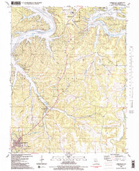
1983 Map of Camdenton
USGS Topo · Published 1983About this map
The Osage River and the expansive Lake of the Ozarks define the geography of central Missouri during this era of significant recreational development. The map reveals a landscape shaped by the 1931 impoundment of the river, which displaced the original town of Old Linn Creek, seen here as a distinct area separate from the relocated Linn Creek. To the south, Camdenton serves as a regional hub, featuring the Vo-Tech School and a nearby Rodeo Arena.
Find a feature on this map
70 named features on this map. Tap any name to fly to it.
Don’t see what you’re looking for? This feature index may not catch every label — zoom into the map to look around manually.
Map Details
Editions of this 1983 Camdenton Map
2 editions found
Other maps of this area

1888 · Versailles
USGS Topo · 1:125,000

1893 · Versailles
USGS Topo · 1:125,000

1932 · Versailles No 4
USGS Topo · 1:48,000

1933 · Stoutland
USGS Topo · 1:62,500

1934 · Macks Creek
USGS Topo · 1:48,000

1934 · Camdenton
USGS Topo · 1:24,000

1934 · Purvis
USGS Topo · 1:24,000

1934 · Toronto
USGS Topo · 1:24,000

1934 · Lake Ozark
USGS Topo · 1:24,000

1934 · Bagnell
USGS Topo · 1:24,000