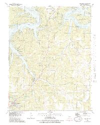
1983 Map of Camdenton
USGS Topo · Published 1983About this map
The Osage River and the expansive Lake of the Ozarks define this landscape in the early 1980s, revealing the geographical shift of settlements following the reservoir's creation. The distinction between Old Linn Creek and the relocated Linn Creek illustrates the profound impact of the hydroelectric project on local topography and community planning. Along the Grandlaize Arm, numerous recreational sites like Camp Clover Point and Camp Pa He Tsi dot the shoreline of Osage Beach State Park, signaling the area's transition into a major tourism hub.
Find a feature on this map
77 named features on this map. Tap any name to fly to it.
Don’t see what you’re looking for? This feature index may not catch every label — zoom into the map to look around manually.
Map Details
Editions of this 1983 Camdenton Map
2 editions found
Other maps of this area

1888 · Versailles
USGS Topo · 1:125,000

1893 · Versailles
USGS Topo · 1:125,000

1932 · Versailles No 4
USGS Topo · 1:48,000

1933 · Stoutland
USGS Topo · 1:62,500

1934 · Macks Creek
USGS Topo · 1:48,000

1934 · Camdenton
USGS Topo · 1:24,000

1934 · Purvis
USGS Topo · 1:24,000

1934 · Toronto
USGS Topo · 1:24,000

1934 · Lake Ozark
USGS Topo · 1:24,000

1934 · Bagnell
USGS Topo · 1:24,000