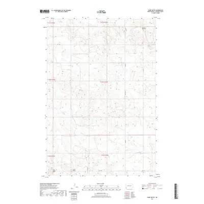
2017 Map of Camel Butte
USGS Topo · Published 2017About this map
Medicine Pole Hills rise across the high plains of Bowman County, framing a landscape defined by the upper reaches of the N Fork Grand River. This 2017 study details the drainage network of western North Dakota, where the headwaters of Skull Cr, Horse Cr, and Spring Cr carve through the prairie terrain. The prominent elevations of Camel Butte and Long Grassy Butte stand as distinct landmarks above the surrounding rangeland. The map illustrates a contemporary pattern of land use and access, marked by gravel routes like Rhame Rd and infrastructure-focused corridors such as Oil Well Rd. This survey captures the region's character as a sparsely settled agricultural and energy-producing landscape, preserving the exact layout of township sections and the winding paths of seasonal watercourses before they join the larger Missouri River watershed.
Find a feature on this map
18 named features on this map. Tap any name to fly to it.
Don’t see what you’re looking for? This feature index may not catch every label — zoom into the map to look around manually.
Map Details
Editions of this 2017 Camel Butte Map
This is the sole edition of this map. No revisions or reprints were ever made.
Other maps of this area

1935 · Buffalo
USGS Topo · 1:125,000

1953 · Dickinson
USGS Topo · 1:250,000

1954 · Lemmon
USGS Topo · 1:250,000

1957 · Dickinson
USGS Topo · 1:250,000

1957 · Lemmon
USGS Topo · 1:250,000

1969 · Ladner NE
USGS Topo · 1:24,000

1969 · Table Mountain
USGS Topo · 1:24,000

1973 · Camel Butte
USGS Topo · 1:24,000
1973 · Rhame SE
USGS Topo · 1:24,000

1973 · Griffin
USGS Topo · 1:24,000