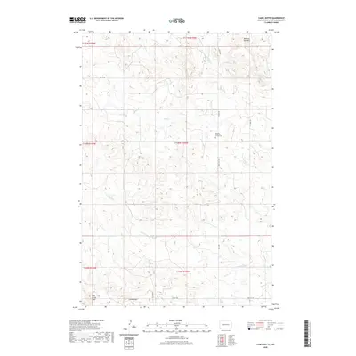
2020 Map of Camel Butte
USGS Topo · Published 2020About this map
Bethany Lutheran Church Cem stands as a central spiritual and historical landmark in this corner of Bowman County, situated amidst the high plains terrain of southwestern North Dakota. The landscape is defined by significant elevations and drainage systems, most notably the prominent Camel Butte and Long Grassy Butte to the south, and the Medicine Pole Hills rising in the northeast. This 2020 survey details a region where the rural economy and natural geography are closely linked. The network of intermittent streams, including Skull Cr and Horse Cr, feeds into the N Fork Grand River, which cuts across the southeastern portion of the quadrangle. Local transportation is facilitated by sections of Rhame Rd and Oil Well Rd, reflecting the area's dual reliance on ranching and energy resources. These features provide a clear picture of the modern prairie landscape, where traditional landmarks like the Bethany Lutheran Church Cem remain vital anchors for the local community.
Find a feature on this map
20 named features on this map. Tap any name to fly to it.
Don’t see what you’re looking for? This feature index may not catch every label — zoom into the map to look around manually.
Map Details
Editions of this 2020 Camel Butte Map
This is the sole edition of this map. No revisions or reprints were ever made.
Other maps of this area

1935 · Buffalo
USGS Topo · 1:125,000

1953 · Dickinson
USGS Topo · 1:250,000

1954 · Lemmon
USGS Topo · 1:250,000

1957 · Dickinson
USGS Topo · 1:250,000

1957 · Lemmon
USGS Topo · 1:250,000

1969 · Ladner NE
USGS Topo · 1:24,000

1969 · Table Mountain
USGS Topo · 1:24,000

1973 · Camel Butte
USGS Topo · 1:24,000
1973 · Rhame SE
USGS Topo · 1:24,000

1973 · Griffin
USGS Topo · 1:24,000