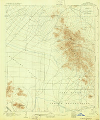
1906 Map of Camelsback
USGS Topo · Published 1930About this map
The arid landscape of central Arizona at the turn of the century is defined by the contrast between its prominent mountain ranges and early hydraulic infrastructure. Topographer T. M. Bannon and his team surveyed this terrain in the early 1900s, documenting the expanse of Paradise Valley before the suburban growth of Phoenix reached these foothills. The map details the rugged topography of the McDowell Mts, including McDowell Pk and Thompson Pk, as well as the distinctive Camelsback Mtn to the south.
Find a feature on this map
16 named features on this map. Tap any name to fly to it.
Don’t see what you’re looking for? This feature index may not catch every label — zoom into the map to look around manually.
Map Details
Editions of this 1906 Camelsback Map
3 editions found
Other maps of this area

1904 · Camelback
USGS Topo · 1:62,500

1904 · Desert Well
USGS Topo · 1:62,500

1904 · Ft. McDowell
USGS Topo · 1:62,500

1906 · Camelsback
USGS Topo · 1:62,500

1906 · Ft. McDowell
USGS Topo · 1:62,500

1906 · Desert Well
USGS Topo · 1:62,500

1912 · Phoenix
USGS Topo · 1:62,500

1913 · Mesa
USGS Topo · 1:62,500

1914 · Phoenix
USGS Topo · 1:62,500

1915 · Mesa
USGS Topo · 1:62,500