
1906 Map of Camelsback
USGS Topo · Published 1906About this map
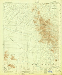
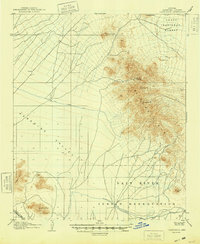
Paradise Valley is presented here during the first decade of the twentieth century, appearing as a broad alluvial plain bounded by the steep crests of the Mc Dowell Mts and Phoenix Mts. The territory shows a landscape on the verge of significant hydraulic change, with the Old Verde Canal tracing a path across the upper desert while the Arizona Canal defines the southern irrigation boundary. At this time, infrastructure was sparse, limited to primitive roads leading toward Fort McDowell and Desert Well.
Find a feature on this map
30 named features on this map. Tap any name to fly to it.
Don’t see what you’re looking for? This feature index may not catch every label — zoom into the map to look around manually.
Map Details
Editions of this 1906 Camelsback Map
3 editions found
Other maps of this area

1904 · Camelback
USGS Topo · 1:62,500

1904 · Desert Well
USGS Topo · 1:62,500

1904 · Ft. McDowell
USGS Topo · 1:62,500

1906 · Ft. McDowell
USGS Topo · 1:62,500

1906 · Desert Well
USGS Topo · 1:62,500

1912 · Phoenix
USGS Topo · 1:62,500

1913 · Mesa
USGS Topo · 1:62,500

1914 · Phoenix
USGS Topo · 1:62,500

1915 · Mesa
USGS Topo · 1:62,500

1930 · Cave Creek
USGS Topo · 1:125,000