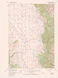
1950 Map of Cameron
USGS Topo · Published 1970About this map
The Madison Bench overlooks a high-mountain landscape where agricultural rills and alpine peaks converge. In the early post-war era, the settlement of Cameron served as a central point for a network of working livestock operations, including the Olsen Ranch, Armitage Ranch, and Storey Ranch. The terrain shifts dramatically from the open valley floor to the dense timber of the Madison National Forest and Beaverhead National Forest. This 1950 field check captures the area's mid-century industrial footprint, from timber production at the Krauss Sawmill to mineral extraction at the Mountain Talc Mine and Ruby Mine. High-elevation landmarks like The Helmet and No Man Peak define the eastern skyline, while the drainage of Indian Creek and Wolf Creek support the region's irrigation and ranching economy.
Find a feature on this map
42 named features on this map. Tap any name to fly to it.
Don’t see what you’re looking for? This feature index may not catch every label — zoom into the map to look around manually.
Map Details
Editions of this 1950 Cameron Map
5 editions found
Other maps of this area

1888 · Three Forks
USGS Topo · 1:250,000

1894 · Three Forks
USGS Topo · 1:250,000

1895 · Three Forks
USGS Topo · 1:250,000

1947 · Bozeman
USGS Topo · 1:250,000

1948 · Bozeman
USGS Topo · 1:250,000

1949 · Varney
USGS Topo · 1:62,500

1949 · Ennis
USGS Topo · 1:62,500

1950 · Cliff Lake
USGS Topo · 1:62,500

1950 · Hebgen Dam
USGS Topo · 1:62,500

1950 · Cameron
USGS Topo · 1:62,500