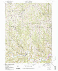
1994 Map of Cameron
USGS Topo · Published 1998About this map
Cameron sits at the confluence of several narrow valleys in Monroe County, serving as a focal point for a landscape defined by its high, named ridges. The terrain is crisscrossed by an extensive network of ridgeline roads, including Pugh Road and Gardner Ridge Road, which connect small upland communities and family landmarks. This 1990s inspection reflects a rural Ohio landscape where the historical footprint of early settlements remains visible through numerous country churches like Bethel Ch and Zion Ch, alongside cemeteries such as Pugh Cem and Case Cem.
Find a feature on this map
76 named features on this map. Tap any name to fly to it.
Don’t see what you’re looking for? This feature index may not catch every label — zoom into the map to look around manually.
Map Details
Editions of this 1994 Cameron Map
This is the sole edition of this map. No revisions or reprints were ever made.
Other maps of this area

1905 · Clarington
USGS Topo · 1:62,500

1905 · New Matamoras
USGS Topo · 1:62,500

1905 · Woodsfield
USGS Topo · 1:62,500

1906 · New Martinsville
USGS Topo · 1:62,500

1924 · New Martinsville
USGS Topo · 1:62,500

1924 · New Matamoras
USGS Topo · 1:62,500

1926 · New Martinsville
USGS Topo · 1:62,500

1926 · New Matamoras
USGS Topo · 1:62,500

1935 · Clarington
USGS Topo · 1:62,500

1940 · Clarington
USGS Topo · 1:62,500