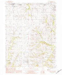
1984 Map of Cameron West
USGS Topo · Published 1984About this map
Osborn and Cameron anchor the northern reaches of this Missouri landscape, which straddles the line between De Kalb and Clinton counties. The area's transit history is etched into the terrain, visible where the Burlington Northern tracks intersect with an old railroad grade that once served the rural community of West Keystone. Further south, the town of Turney sits near the headwaters of several drainages, illustrating the ridge-top settlement patterns typical of this region.
Find a feature on this map
29 named features on this map. Tap any name to fly to it.
Don’t see what you’re looking for? This feature index may not catch every label — zoom into the map to look around manually.
Map Details
Editions of this 1984 Cameron West Map
This is the sole edition of this map. No revisions or reprints were ever made.
Other maps of this area

1923 · Maysville
USGS Topo · 1:62,500

1924 · Polo
USGS Topo · 1:62,500

1924 · Winston
USGS Topo · 1:62,500

1925 · Plattsburg
USGS Topo · 1:62,500

1925 · Maysville
USGS Topo · 1:62,500

1950 · Kansas City
USGS Topo · 1:250,000

1954 · Kansas City
USGS Topo · 1:250,000

1956 · Kansas City
USGS Topo · 1:250,000

1960 · Kansas City
USGS Topo · 1:250,000
1983 · Amity
USGS Topo · 1:24,000