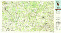
1981 Map of Camilla
USGS Topo · Published 1982About this map
Kolomoki Mounds State Park and the archaeological heritage of the Chattahoochee valley anchor the western edge of this Southwest Georgia landscape. The regional geography is dominated by the broad, winding Flint River, which serves as a natural boundary between several counties and creates a network of swampy bottoms and islands like Goat Island. Settlement patterns in the early 1980s reflect a series of agricultural hubs such as Camilla, Blakely, and Colquitt, connected by the Central of Georgia and Seaboard Coast Line railroads. The terrain transitions from the well-watered basins of Ichawaynochaway Creek and Spring Creek to the notably flat expanses of The Level. Local commerce and community life are marked by rural landmarks including Ivey Mill, Red Store Crossroads, and Mt Zion Ch, providing a detailed view of the rural infrastructure before modern expansion.
Find a feature on this map
128 named features on this map. Tap any name to fly to it.
Don’t see what you’re looking for? This feature index may not catch every label — zoom into the map to look around manually.
Map Details
Editions of this 1981 Camilla Map
2 editions found
Other maps of this area

1952 · Bascom
USGS Topo · 1:24,000

1953 · Dothan
USGS Topo · 1:250,000

1953 · Waycross
USGS Topo · 1:250,000

1954 · Dothan
USGS Topo · 1:250,000

1954 · Steam Mill
USGS Topo · 1:24,000

1954 · Desser
USGS Topo · 1:24,000

1954 · Valdosta
USGS Topo · 1:250,000

1954 · Tallahassee
USGS Topo · 1:250,000

1955 · Dothan
USGS Topo · 1:250,000

1955 · Bainbridge
USGS Topo · 1:62,500