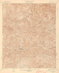
1940 Map of Camp Bonita
USGS Topo · Published 1940About this map
Camp Bonita sits at the confluence of the river forks within the Angeles National Forest, serving as a central hub in a landscape defined by steep canyons and mining history. Surveyed in the 1930s, this area of the San Gabriel Mountains reveals an era when resource extraction and mountain recreation coexisted. The Allison Mine and Baldora Mine are located high on the ridges near Iron Mtn, while down in the valleys, various camps like Weber Camp and Williams Camp provided footing for early forest visitors. Deep incisions such as The Narrows on the East Fork San Gabriel River highlight the difficult terrain that forced travel onto routes like the Highline Trail. Further south, Tanbark Flats and the San Gabriel Guard Station indicate the early infrastructure for forest management and fire prevention, including numerous mapped Firebreak lines.
Find a feature on this map
42 named features on this map. Tap any name to fly to it.
Don’t see what you’re looking for? This feature index may not catch every label — zoom into the map to look around manually.
Map Details
Editions of this 1940 Camp Bonita Map
3 editions found
Other maps of this area

1894 · Pomona
USGS Topo · 1:62,500

1897 · Pomona
USGS Topo · 1:62,500

1897 · Cucamonga
USGS Topo · 1:62,500

1898 · Pomona
USGS Topo · 1:62,500

1900 · Cucamonga
USGS Topo · 1:62,500

1901 · Southern California Sheet No. 1
USGS Topo · 1:250,000

1903 · Rock Creek
USGS Topo · 1:62,500

1903 · Cucamonga
USGS Topo · 1:62,500

1903 · San Antonio
USGS Topo · 1:62,500

1904 · Pomona
USGS Topo · 1:62,500