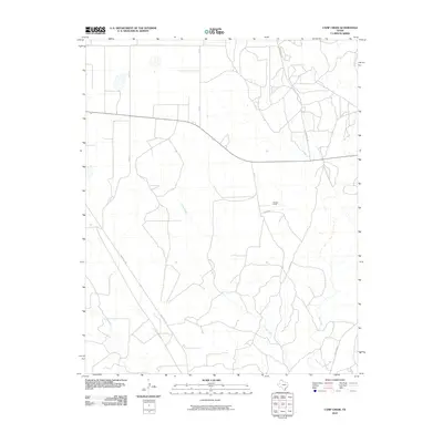
2010 Map of Camp Creek
USGS Topo · Published 2010About this map
Herring Ranch stands as a primary landmark in this section of the Texas Panhandle, situated in a landscape defined by the drainage basins of several prominent waterways. The terrain is marked by the winding paths of Camp Creek, Big Creek, and Bugbee Creek, which cut through the Moore County plains. This 2010 survey illustrates a sparsely populated ranching and agricultural region where the transportation network relies on a series of secondary routes, including Ranch Rd 1923 and Fm 1923 N. The layout of the roads, such as Ranch Rd 1319 and several county roads like Co Rd 4, suggests a territory organized around large landholdings and watershed management. The map provides a clear view of the hydrological patterns and rural infrastructure that sustained the local ranching economy in the early 21st century.
Find a feature on this map
11 named features on this map. Tap any name to fly to it.
Don’t see what you’re looking for? This feature index may not catch every label — zoom into the map to look around manually.
Map Details
Editions of this 2010 Camp Creek Map
This is the sole edition of this map. No revisions or reprints were ever made.
Other maps of this area

1939 · Sanford
USGS Topo · 1:62,500

1953 · Sanford
USGS Topo · 1:24,000

1953 · Stinnett
USGS Topo · 1:24,000

1953 · Evans Canyon
USGS Topo · 1:24,000

1953 · Pringle
USGS Topo · 1:24,000

1953 · Borger
USGS Topo · 1:24,000

1954 · Amarillo
USGS Topo · 1:250,000

1958 · Amarillo
USGS Topo · 1:250,000
1970 · Sanford
USGS Topo · 1:24,000

1970 · Borger
USGS Topo · 1:24,000