
1970 Map of Borger
USGS Topo · Published 1973About this map
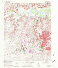
The Dial Oil Field and Borger Oil Field define the industrial character of this landscape north of the Canadian River during the early 1970s. The city of Borger is the central hub, showing a dense street grid including Main St, Jefferson St, and Sixth St, alongside prominent institutions like Frank Phillips College and Coronado Sch. The map reveals a complex infrastructure of the era, with the Atchison Topeka and Santa Fe railroad serving a network of chemical and carbon black plants south of Bunavista. Local geography is shaped by water features such as Rock Creek and Weatherly Lake, while the northern hills are marked by the Johnson Tank Farm and numerous pipelines. This survey documents the intersection of rapid mid-century municipal growth and the heavy petroleum industry that sustained these Texas Panhandle communities.
Find a feature on this map
57 named features on this map. Tap any name to fly to it.
Don’t see what you’re looking for? This feature index may not catch every label — zoom into the map to look around manually.
Map Details
Editions of this 1970 Borger Map
2 editions found
Other maps of this area

1939 · Sanford
USGS Topo · 1:62,500

1953 · Sanford
USGS Topo · 1:24,000

1953 · Plemons
USGS Topo · 1:24,000

1953 · Stinnett
USGS Topo · 1:24,000

1953 · Deal
USGS Topo · 1:24,000

1953 · Borger SE
USGS Topo · 1:24,000

1953 · McBride
USGS Topo · 1:24,000

1953 · Phillips
USGS Topo · 1:24,000

1953 · Borger
USGS Topo · 1:24,000

1954 · Amarillo
USGS Topo · 1:250,000