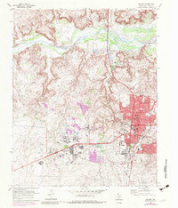
1970 Map of Borger
USGS Topo · Published 1983About this map
Industrial infrastructure and urban growth define this Texas Panhandle landscape, where the Canadian River flows past a concentration of energy-sector developments. The map documents the extensive Borger Oil Field and Dial Oil Field, featuring a network of pipelines, pumping stations, and specialized facilities like the Carbon Black Plant and Johnson Tank Farm. This resource-driven economy is reflected in the surrounding settlements of Bunavista and Electric City, alongside the residential core of Borger.
Find a feature on this map
63 named features on this map. Tap any name to fly to it.
Don’t see what you’re looking for? This feature index may not catch every label — zoom into the map to look around manually.
Map Details
Editions of this 1970 Borger Map
2 editions found

Other maps of this area

1939 · Sanford
USGS Topo · 1:62,500

1953 · Sanford
USGS Topo · 1:24,000

1953 · Plemons
USGS Topo · 1:24,000

1953 · Stinnett
USGS Topo · 1:24,000

1953 · Deal
USGS Topo · 1:24,000

1953 · Borger SE
USGS Topo · 1:24,000

1953 · McBride
USGS Topo · 1:24,000

1953 · Phillips
USGS Topo · 1:24,000

1953 · Borger
USGS Topo · 1:24,000

1954 · Amarillo
USGS Topo · 1:250,000