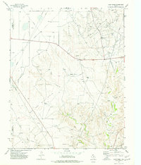
1974 Map of Camp Creek
USGS Topo · Published 1977About this map
Gas and oil field development dominates this mid-1970s landscape along the Moore Co Hutchinson Co border. The map reveals an intensive industrial infrastructure, characterized by a dense network of gas wells, oil wells, and pumping stations linked by numerous pipelines. In contrast to this energy production, the Herring Ranch represents the region's agricultural roots, situated amidst the natural drainage of Camp Creek and Big Creek. Of particular interest to local historians is the Old RR Grade in the southeastern corner, marking a former transportation route that predates the modern energy-driven economy. A significant Aqueduct also traverses the terrain, highlighting the critical management of water resources in the Texas Panhandle during this era of growth.
Find a feature on this map
17 named features on this map. Tap any name to fly to it.
Don’t see what you’re looking for? This feature index may not catch every label — zoom into the map to look around manually.
Map Details
Editions of this 1974 Camp Creek Map
This is the sole edition of this map. No revisions or reprints were ever made.
Other maps of this area

1939 · Sanford
USGS Topo · 1:62,500

1953 · Sanford
USGS Topo · 1:24,000

1953 · Stinnett
USGS Topo · 1:24,000

1953 · Evans Canyon
USGS Topo · 1:24,000

1953 · Pringle
USGS Topo · 1:24,000

1953 · Borger
USGS Topo · 1:24,000

1954 · Amarillo
USGS Topo · 1:250,000

1958 · Amarillo
USGS Topo · 1:250,000
1970 · Sanford
USGS Topo · 1:24,000

1970 · Borger
USGS Topo · 1:24,000