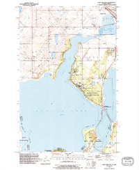
1994 Map of Camp Grafton
USGS Topo · Published 1995About this map
Devils Lake dominates this landscape, its expansive waters defining the boundaries between the townships of Grand Harbor and Creel. At the center of the sheet, the Gilbert C Grafton State Military Reservation and the Camp Grafton facility occupy the peninsula overlooking Creel Bay. The map provides a detailed look at the interface between military, recreational, and tribal lands, with the Sioux Indian Reservation and Sullys Hill National Game Preserve bordering the southern reaches of the lake near Mission Bay.
Find a feature on this map
36 named features on this map. Tap any name to fly to it.
Don’t see what you’re looking for? This feature index may not catch every label — zoom into the map to look around manually.
Map Details
Editions of this 1994 Camp Grafton Map
This is the sole edition of this map. No revisions or reprints were ever made.
Other maps of this area

1928 · Tokio
USGS Topo · 1:62,500

1931 · Oberon
USGS Topo · 1:62,500

1931 · Tokio
USGS Topo · 1:62,500

1931 · Devils Lake
USGS Topo · 1:62,500

1932 · Grahams Island
USGS Topo · 1:62,500

1950 · Tokio
USGS Topo · 1:24,000

1950 · Grahams Island
USGS Topo · 1:62,500

1950 · Devils Lake
USGS Topo · 1:62,500

1950 · Oberon
USGS Topo · 1:62,500

1951 · Crow Hill
USGS Topo · 1:24,000