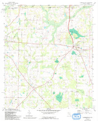
1982 Map of Campbellton
USGS Topo · Published 1993About this map
Campbellton and Graceville anchor this northern Florida landscape, where the border between Florida and Alabama meets at the junction of Jackson, Houston, and Geneva counties. The terrain is defined by a dense network of ponds and wetlands, including Brantley Pond, Rum Pond, and Grant Pond, which served as vital landmarks for local families and agricultural life. This 1982 map, based on fieldwork from the late 1970s, captures the rural community structure through its many country churches such as St Marys Ch and New Bethel Ch, alongside family-named sites like Gainer Cem. Economic and infrastructure markers include a localized Claypit and a Landing Strip, reflecting the mix of traditional land use and mid-century transitions in the Florida Panhandle. Notable topographical features like Registered Bay and the meandering Spring Creek illustrate the natural drainage patterns that shaped the placement of roads and small settlements like Ellaville and Jacobs.
Find a feature on this map
39 named features on this map. Tap any name to fly to it.
Don’t see what you’re looking for? This feature index may not catch every label — zoom into the map to look around manually.
Map Details
Editions of this 1982 Campbellton Map
2 editions found
Other maps of this area

1942 · Enterprise
USGS Topo · 1:125,000

1950 · Chipley
USGS Topo · 1:24,000

1951 · Graceville
USGS Topo · 1:24,000

1951 · Chipley
USGS Topo · 1:24,000

1952 · Cottondale East
USGS Topo · 1:24,000

1952 · Campbellton
USGS Topo · 1:24,000

1952 · Cottondale West
USGS Topo · 1:24,000

1952 · Sills
USGS Topo · 1:24,000

1953 · Dothan
USGS Topo · 1:250,000

1954 · Dothan
USGS Topo · 1:250,000